From a sacred volcanic monolith and thriving estuary to a working harbor town known as “Three Stacks and a Rock,” Morro Bay’s story is a layered blend of nature, maritime labor, industry, and conservation.

Long before Morro Bay became a destination for birders, kayakers, and seafood lovers, it was defined by two natural forces: a massive volcanic plug—Morro Rock—and a protected coastal estuary that offered food, shelter, and travel routes. The rock, visible for miles, is part of the “Nine Sisters,” a chain of ancient volcanic peaks running along California’s Central Coast.
For Indigenous peoples of this region—often described in historical sources as the Chumash and Salinan—Morro Rock has been regarded as a sacred place, woven into cultural memory and ceremony. The bay’s wetlands and tidal flats supported fishing, shellfish gathering, and seasonal lifeways. Even today, the estuary remains one of Morro Bay’s defining features: eelgrass beds, mudflats, and salt marshes that shelter fish, invertebrates, and migratory birds.
Morro Bay’s geography also shaped how outsiders first encountered it. From the open Pacific, Morro Rock acts like a landmark “beacon,” while the bay itself offers calmer water—though the entrance has historically been shallow, shifting, and sometimes treacherous. That tension between “safe harbor” and “dangerous bar” becomes a recurring theme throughout Morro Bay’s development.
European exploration along this coast accelerated in the 1500s–1700s. Historical accounts commonly connect the name “Morro” to Spanish descriptions of a rounded headland or dome-like rock. During the 1769 Portolá expedition—the first overland Spanish exploration of Alta California— the party camped near today’s Morro Bay area and recorded the prominent rock in expedition notes.
As Spanish colonization spread through California, Indigenous communities across the region faced profound disruption: disease, forced relocation, missionization, and the loss of access to traditional lands and resources. The Morro Bay area, situated between growing colonial settlements, ranchos, and later American-era development, was pulled into broader economic systems that prioritized livestock, land subdivision, and extractive uses of coastal resources.
In the late 1800s, Morro Rock itself began to physically change. Quarrying and blasting removed large amounts of stone over decades—material that would be used in coastal infrastructure projects. The rock, once larger and more “island-like,” became tied to the mainland via road and harbor modifications, further transforming the shoreline.
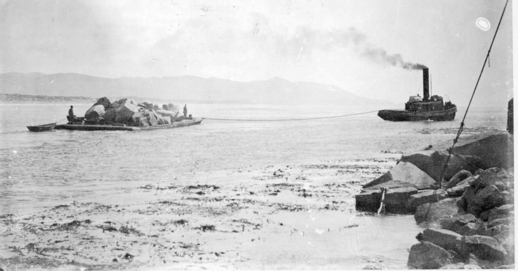
By the early 1900s, Morro Bay’s identity increasingly centered on the water: fishing, clamming, and later organized harbor and waterfront activity. Families worked the tides for food and income, and the shoreline began to reflect an economy built around boats, docks, and maritime trade.
But “working waterfront” also required engineering. The bay entrance and channels needed dredging and protection from storms and sand movement. Through the 1900s—especially around the World War II era—coastal infrastructure expanded, including protective breakwaters and channel improvements. These projects helped stabilize access for commercial and recreational vessels, supporting a fishing industry that would become central to Morro Bay’s public image.
As the harbor grew, so did civic institutions connected to it: harbor administration, waterfront businesses, and facilities for visitors. Over time, Morro Bay developed the recognizable rhythm it still has today—boats leaving early, seafood arriving fresh, otters floating in the shallows, and visitors walking the Embarcadero to watch the day’s catch come in.

In the mid-1900s, Morro Bay’s story took a dramatic industrial turn with the construction of the Morro Bay Power Plant. Its tall smokestacks became so visually dominant that they helped inspire the city’s well-known nickname: “Three Stacks and a Rock.” The plant brought jobs and an expanded tax base—changes that helped support the city’s incorporation in 1964.
This era illustrates Morro Bay’s balancing act: a town rooted in natural beauty and marine life, but also shaped by infrastructure and heavy industry. For many residents, the plant was both a symbol of economic stability and a contentious neighbor. The facility ultimately ceased operations in 2014, marking the end of one of Morro Bay’s defining industrial chapters.
After closure, the stacks and plant site remained a focal point in local debate about redevelopment and community identity— a reminder that Morro Bay’s “history” is not just past tense, but an ongoing argument about what belongs on the shoreline and why.

By the late 20th century, Morro Bay became a case study in how a community can pivot toward stewardship. The estuary—so central to Morro Bay’s ecological health and visitor economy—faced mounting pressures: sedimentation, water quality challenges, habitat loss, and the cumulative impacts of development across the watershed.
In the 1990s, local and regional efforts helped secure major recognition and support for long-term restoration and management. In 1995, Morro Bay was selected for the U.S. Environmental Protection Agency’s National Estuary Program, a designation intended to support community-based conservation planning and federal-state-local partnership.
Modern Morro Bay still carries all its earlier layers: Indigenous significance, Spanish-era naming and exploration history, a harbor economy built by working families, and the imprint of industrial infrastructure. Yet the city’s trajectory increasingly emphasizes what makes the place irreplaceable: a living estuary, a vibrant waterfront, and a landscape dominated by one unforgettable rock.